
The Longitude Prize
From the design of the most accurate clock ever to the looming end of modern medicine as we know it
Antibiotics and antibiotic resistance
The beginning of the 20th century witnessed a revolution of modern medicine with the discovery of the first compounds that could effectively treat bacterial infections. The availability of antibiotics like penicillin, sulfonamides and streptomycin suddenly allowed doctors to cure diseases that had been untreatable and that had been causing devastating outbreaks throughout human history, like the plague, typhoid and cholera. Common ailings could be alleviated, and the duration and severity of serious infections ameliorated. Wound infections became manageable, which opened new ways of surgical treatments that were previously unthinkable.
Antibiotics are undoubtedly one of the most important medical advances ever. And we take their ready availability nowadays for granted — whether we have toothache, a chest infection, or undergo abdominal surgery or an organ transplantation.
But the increasing use of antibiotics came at a cost.

A selection of modern antibiotics
Many bacteria quickly adapted to the new pressure and acquired resistances to these treatments, from the emergence of MRSA (methicillin-resistant Staphylococcus aureus), a frequent cause of hospital-acquired infections, to vancomycin-resistant Enterococcus (vancomycin being often used to treat MRSA), and finally to real “superbugs” like carbapenem-resistant bacteria that can only be treated with very few so-called last resort compounds like colistin. “Last resort” as in: “out of sheer desperation for the lack of better alternatives”. Colistin is a nasty drug that can damage your kidneys and your nervous system and is only used when all other options have been exhausted.
And then, in 2015, resistance against colistin began to appear, creating bacterial strains that are literally untreatable. So far, they have mainly been found in the environment and have not caused any major outbreak of infections. But as a society we are dancing on the edge of a volcano that could erupt any moment.
Several factors have accelerated the global spread of antimicrobial resistance, including inappropriate use of antibiotics when they are actually not needed, over-the-counter availability without prescription, overuse of antibiotics for livestock and fish farms, knowledge gaps in how to best manage antibiotics, and a lack of accurate, practical, affordable and rapid diagnostic testing.
The World Health Organisation (WHO) already warned in 2012 of the threat of a potential “end of modern medicine as we know it”, where antibiotics would lose their effectiveness, infections could become untreatable, and procedures such as Caesarean sections, hip replacements and cancer treatments could soon become too risky to perform.
Antimicrobial resistance has become one of the top global health threats.
Rapid diagnosis at the point of care
Scientists and doctors believe that the development of rapid point-of-care diagnostic tests is essential to ensure and deliver improved use of antibiotics, to enable health professionals to administer the right drug at the right time. Today, tests used to diagnose bacterial infections have to be carried out in special laboratories where it typically takes 2-3 days to produce an accurate test result, which involves having to grow the organisms in culture and then identifying them using microbiological or molecular methods.
In the meantime, while waiting for the test results, many patients with suspected infections have to be given treatment immediately, for instance in individuals with life-threatening conditions like acute sepsis. Waiting 2-3 days for a test result is simply not an option in those cases. As a result, many emergency patients but often also individuals with milder symptoms are given antibiotics, “just in case” they may have a bacterial infection. Which is in many cases a life-saving remedy but in other cases leads to unnecessary prescriptions and overuse of antibiotics in people who don’t need them.
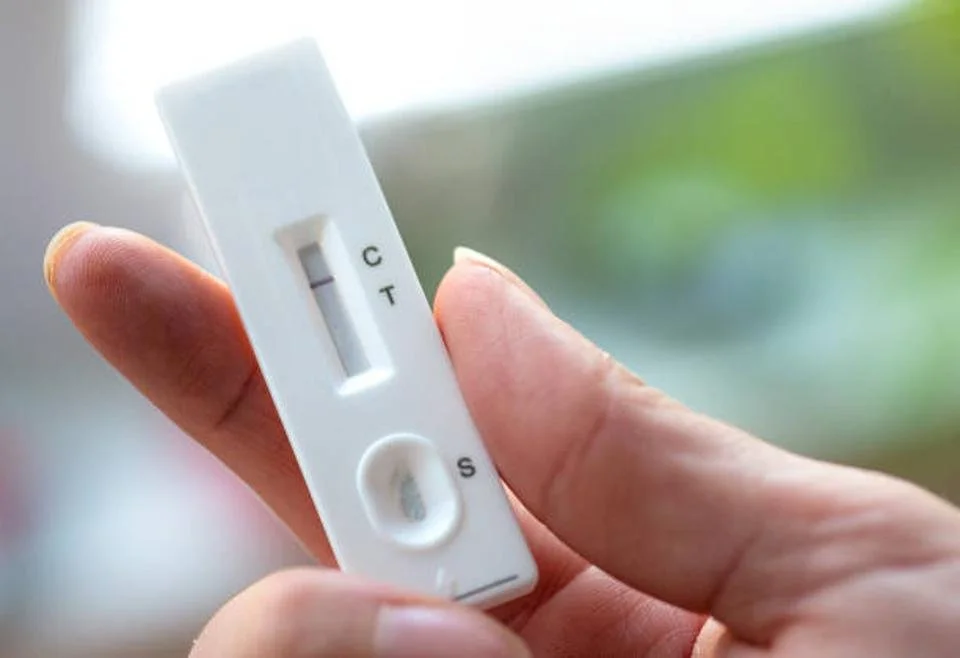
A COVID-19 lateral flow test showing a negative result. — Getty Images/iStockphoto
To shorten this waiting period of 2-3 days, a new generation of diagnostic tests is needed to quickly identify the presence of a bacterial infection, ideally in just half an hour, and understand which antibiotic will be an effective treatment. A bit like the commonly used lateral flow tests for COVID-19 that we have all become all too familiar with over the past year — but a test that covers all possible infections and not just a single type.
Providing clinicians with such novel tests would empower them to make the best clinical and diagnostic decisions in the interest of their patients and for a future where antibiotics continue to work.
In order to encourage the development of new tests, the so-called Longitude Prize was launched in 2014 — a £10 million prize fund to reward inventors who manage to design a test that will conserve antibiotics for future generations and that is accurate, rapid, affordable and easy to use anywhere in the world.
Without rapid and powerful tests combined with best practice in antibiotic usage, the efficacy of new antimicrobial treatments will be undermined in the long term. And as a modern society we clearly cannot afford to go back to a “pre-antibiotic era”, in which common childhood diseases and deadly pandemics might come back and in which even minor injuries could pose the risk of developing untreatable wound infections.
So far, so good. But why call it the “Longitude Prize”?
Well, this takes us more than 300 years back, to a time when the measurement of the geographical longitude of a given location on the globe was one of the most important unresolved questions in the field of science and technology.
Colonisation and global trade
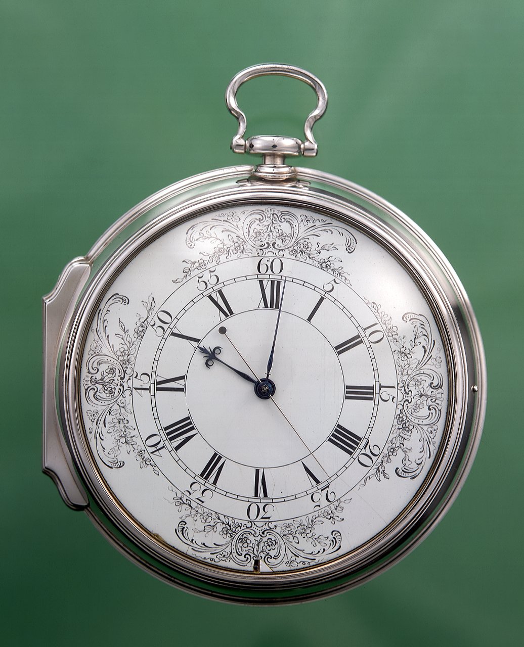
Marine timekeeper H4, John Harrison's prize-winning longitude watch (1759). — National Maritime Museum, Greenwich, London.
Long voyages were all the rage in the 16th and 17th century. The first European ships had successfully explored the coasts of North and South America and had reached India both eastwards by sailing around tip of Africa, and westwards around South America. The European countries were busy with dividing the newly discovered parts of the world between them, with Spain setting up a colonial empire in Central and South America, Portugal in Brazil and England in North America, alongside England, France, Portugal, the Netherlands and other countries all wanting pieces of Africa, India or South-East Asia – to trade natural resources like gold, cotton and spices, as well as slaves.
But sailing across the seas was a dangerous business and could last for weeks, or even months. Most of all it required precise navigation – based on an exact determination of one’s location. Nowadays this may seem trivial: we are used to having a global positioning system (GPS) wherever we are, which is achieved by modern satellite technology and operates applications like the SatNav in our cars and Google maps on our computers. In contrast, the ancient sailors had to rely on the position of the sun and the stars to calculate where they were.
Which brings us to latitude and longitude, together defining one’s position anywhere on Earth.
Latitude: how far is it to the North Pole?
Latitude marks the distance from the equator, which is set at 0° latitude. The more you go North, the more the latitude increases. The North Pole itself has a latitude of 90° N (North). London is at 51.5° N, which means it is a bit closer to the North Pole than to the equator (as you would have probably guessed from the usual weather there).

So how do you measure your latitude when you don’t have your mobile phone with you, for instance when you are a 17th century British sailor crossing the Atlantic Ocean?
Well, it turns out that this is pretty easy, as long as you know where the North Star is, in the nightly constellation of the Little Bear (or ‘Little Dipper’ in North America). The North Star shines exactly above your head if you are at the North Pole, and if you were to stay long enough to watch (despite the cold and the hungry polar bears) you would see that the whole starry sky actually spins around that tine little dot, which itself never changes its position. To see the North Star you would have to look straight up, at an angle of 90°.
Further down South, say in London, on one of those rare nights when you can actually see the stars, you would see the same spectacle – the whole sky spinning around the North Star, which itself stays fixed. Only that this time the North Star is not above you but at a certain angle in front of you. Which corresponds directly with the latitude of your location. So measuring your latitude is easy – it’s the angle between the horizon in front of you and the North Star. In London it’s an angle of 51.5°.
Now longitude is a bit trickier.
Longitude: what time is it in Greenwich right now?
Longitude is the distance between what is called a prime meridian (defined as 0°) and one’s location in East-West orientation. Historically, many countries established their own prime meridians, usually falling within their own territory, for instance their capital. Britain established its own meridian in 1721, passing through the newly established Royal Observatory at Greenwich, London — and after years of heated debates around the world, the Greenwich meridian was eventually established as the only internationally recognised prime meridian. That was in 1884.
Longitude is complicated by the fact that the Earth rotates. In 24 hours it makes one full turn around its axis, or 360°. Which corresponds to 15° each hour. But this rotation also suggests a way to measure the longitude of your location. Now what you need is an event that you can observe easily in different parts of the world, for instance the moment the sun reaches its highest peak in the sky during the day (noon). Or the beginning of a lunar eclipse. Or the movement of the moons around the planet Jupiter. If two people in different places observe the same astronomical event and compare the time when it happens, they can calculate how far from each other they are.
So let’s say you are in London and set your time to 12:00 noon when the sun is at its highest position (which works best on a sunny day so you may have to be patient). At what time would someone in New York make the same observation? Well, it needs the Earth to rotate far enough so that the sun can be at its highest in New York. You could ask someone in New York to give you a call when it’s 12:00 noon there. And you would find that your own local time would show that it’s already 5:00 pm in London. That means the time difference is 5 hours. With 15° per hour this corresponds to a longitude of 75° W (West) for New York. And if you know the circumference of the Earth you can now calculate the distance between London and New York (5567 kilometres to be precise, or 3459 miles). Maybe you even understand now why the abbreviation ‘pm’ stands for post meridiem - technically 5pm means it’s been 5 hours since the sun passed over your own meridian.
Now back to our 17th century sailors in the middle of the ocean. They couldn’t just phone someone and ask what time it was back home! Instead they needed a clock. And not just any clock.
They needed the most reliable clock in the world.
The Longitude Act 1714
In those days, clocks were notoriously unreliable. The best ones had a pendulum that kept them going at a steady pace, but after a while they would just be hopelessly ahead of time, or behind. Which is fine when you are on land and can readjust the clock regularly. On a ship, with the constant ups and downs of the waves, a pendulum simply wouldn’t work. And the drastic changes in humidity (think heavy storm here!) and temperature on long journeys didn’t exactly help the time-keeping precision either.
So for hundreds of years, sailors had to make an educated guess of how far to the West or East they had sailed, and how long their voyage had taken. Imagine having to draw a map of the world like that! Quite often they were actually pretty good at it and were merely off by a few dozen or a few hundred miles here and there. But especially on longer journeys they could also get it horribly wrong and had to go on extended detours to find the way to their destination. And some unfortunate ships got lost at sea altogether and ran out of food…
Losing precious time on voyages, and losing whole ships with their valuable cargoes, became such an important problem for merchants and businesses that in 1714, the British Parliament passed the Longitude Act, offering a reward of £20,000 🪙 (corresponding to £1.5 million of today’s money 💷) for the first person to come up with a practical solution to determine longitude to an accuracy of half a degree.
(Note that half a degree corresponds to a distance of 55 km (35 miles) at the equator, which is roughly the size of islands like Mallorca and Madeira, with Barbados and Bermuda being even smaller that that.)
The genius watchmaker

Portrait of John Harrison by James King, about 1766. — Science Museum, London
Enter John Harrison, a carpenter from Yorkshire who had taken up clock-making just a year before the award was announced. He had no formal training. Yet, somehow he managed to create the most remarkable clocks. In 1735, he presented his first model, the H1, to the governing Board that oversaw the Longitude Prize. It was a highly innovative and incredibly accurate clock with two pendulums – unfortunately not precise enough to win the competition. Still, he received £250, enough funding to be able to continue his work.
Over the coming years he improved the design of his maritime clocks further and presented the models H2 and H3 to the Board. The experts where impressed by his skills and his progress. However, they were not convinced enough to grant him the full prize money. Nevertheless, Harrison managed to obtain a further £2,000 between 1741 and 1755. Probably enough to pay his running costs and keep him going.
He then decided to change tack completely and abandoned pendulum clocks altogether. Instead he designed what looked like an oversized pocket watch. A rather strange move, against the prevailing view that pendulum clocks were far more precise than pocket watches, which had a reputation of being particularly bad timekeepers. And lo and behold, Harrison succeeded in doing what nobody before had thought was doable. His fourth clock, the H4, was completed in 1759. A sheer masterpiece. The most accurate timekeeper at sea the world had ever seen. Its precision not only exceeded Harrison’s previous models H1, H2 and H3, it exceeded by far the requirements of the Longitude Prize to win the full award.
Problem solved!
Copies of the H4 were soon given to the captains of important missions, for instance to James Cook on his journeys to Australia, New Zealand and the South Pacific, and later to William Bligh (commander of the infamous Bounty, the one with the mutiny) on his mission to Tahiti. The H4 in fact allowed Cook to make such accurate charts of remote parts of the world that they would still be in use 150 years later.
And so you will be pleased to learn that after all his hard work and his genius engineering, John Harrison deservedly and proudly received the prize money… errm, actually not. Only half of it, with the Board of the Longitude Prize keeping him waiting and making additional requests. It should actually take him another 24 years, including an appeal to King George III himself, to be finally granted the remainder of the promised prize money, in 1773. Harrison died only three years later, at the age of 82.
Then and now
Coming back to modern times, it is hopefully clear now why the Longitude Prize 2014 was created to replicate the game-changing original award dating back to the year 1714.
Only that this time it is not about making safe voyages to other countries and being able to draw accurate maps of the world. This time it is about ensuring that we can continue to enjoy the benefit of using our current medicines to treat common infections and have the best possible diagnostic tests available.
The Longitude Prize has always been about solving one of the most pressing scientific and technological challenges of our times. 300 years ago it encouraged John Harrison to design the best clocks the world had ever seen.
Who will win it this time?
Maybe you?
Find out more about the Longitude Prize 2014 on their website.